Even the most imaginative of visitors to the Goyt Valley will find it difficult to picture how different the area must have looked before the construction of the two reservoirs.
Before the reservoirs were built the valley was home to a thriving community with many farms, a paint works, a railway, a Victorian mansion, coal mines, a quarry, a school and even a gunpowder factory.
Glimpses of this past life remain in the valley including the romantic ruins of Errwood Hall, and the paths that follow the route of the old Cromford and High Peak railway line and Goytsclough Quarry.
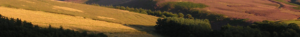
Along with the influence of man, the shape of the valley has been formed over millions of years through ice ages and by the River Goyt that cuts through the valley. The name Goyt is thought to come from the word goit which means a channel for water or a stream from the old English word gote or gota.
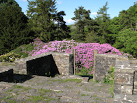
The Grimshawe family of Errwood Hall had a major influence on the valley in the 19th century, bringing prosperity to the small community. They built Errwood Hall, a spectacular Victorian mansion around 1840 which stood until the 1930’s when it was demolished to make way for the reservoirs and avoid pollution. Now all that remains of the hall is its base, but nearby the Grimshawe family cemetery still remains, as well as a Spanish Shrine built in the memory of Miss Dolores, a companion to the Grimshawe family.
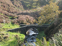
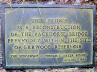
Since Victorian times the valley has been a popular tourist destination, in the 19th century visitors may have walked along the river stopping at the tea rooms in the hamlet of Goyts Bridge, and marvelling at the spectacular suspension bridge that once crossed the river. Little of this history remains, but visitors can still see examples of the past including the old packhorse bridge near Goytsclough Quarry, which was reconstructed after it was removed to make way for Errwood Reservoir.
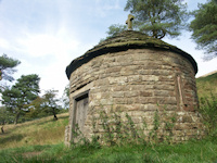
The Cromford and High Peak railway line was first completed in 1831, and a passenger service ran on the line from 1874 but it was ceased in 1877 after a fatal accident. The line used to run alongside where Fernilee Reservoir is sited before reaching the Bunsal Incline where two reservoirs served the stationery steam engines that were used to haul the trains up the steep incline. The track once linked the Peak Forest Canal at Whaley Bridge with the Cromford Canal at Matlock. One of the reservoirs at the top of the Bunsal Incline remains, and visitors can walk along the route of the track with views across the valley before reaching the now closed tunnel.
 The valley has not always been such a peaceful place as it is today, the Chilworth gunpowder factory, open from about 1800 until 1920, and located where Fernilee Reservoir now is often experienced fatal accidents, in 1920 three men were killed in a blast at the site and in the 1880’s a woman worker was killed. In times of drought, when water levels in the reservoirs are very low, some of the flooded remains of the valley can still be seen. Other industry in the valley included a paint factory which employed around 20 people, and was open until the late 19th century.
Medieval packhorse routes and roman roads indicate the valley was a significant trade route, indeed Goytsclough Quarry is thought to be where the well known international haulage and removal company Pickfords started trading in the late 17th century, when Thomas Pickford purchased the quarry. Trains of packhorses were used to transport the stone from the quarry, and rather than returning empty the horses were used to return goods to the area.
 There is also a local legend that a highway man called Pym used to lay in wait to ambush those who used the packhorse route, (at Pym Chair) although it is also thought Pym was a preacher who gave sermons here.
Fernilee was the first reservoir to be built in 1938 by the Stockport Corporation after they purchased the Grimshawe estate, it was not until 1964 that work commenced on the creation of Errwood Reservoir which was officially opened by the Duchess of Kent in June 1968.
Derbyshire Bridge, located about 150 yards from the Derbyshire Bridge car park is so called because it used to be where the county boundaries of Cheshire and Derbyshire met, today the boundary is further to the west.
 Farming has always played a big part in the history of the valley, and the remains of many farm houses remain, sheep still graze in the valley today.
Nearby, England’s second highest public house the Cat and Fiddle standing at 1690 feet or 515 metres above sea level was built towards the end of the 18th century, and has provided a refuge for travellers ever since, (currently closed). Jenkin Chapel, The Church of St John the Baptist, in Saltersford is just to the west of the valley. It was built in 1733 by local farmers with the tower at the front being added 21 years later.